
I stay back! Had a great time at da kahakai with my friends, and now it’s time to get back to our Montana road trip. I have a few more photos from Alpowa Summit to start with.
I took a photo of this mountain that was ʻway off in the distance, but try as I might, I donʻt know which one it is! I know that the Blue Mountains are over in that direction, but which one that is…. dunno. Iʻve tried checking Google Maps and have Googled what it might be, but so far, no luck. Maybe somebody can let me know.

Blue Mountains?
The close-up doesn’t help much, does it?

Blue Mountains?
Well, here’s a video that I took while we were there. It was an excellent place to stretch our legs and enjoy the vastness of the countryside.
Now comes the fun part. We were getting on the long downgrade that winds its way down the hill from Alpowa Summit to Clarkston, Washington. We were on this downgrade in 2009 when we went to Montana for the first time. Here’s what it looks like in GoogleEarth:

This time, I had Nolemana take a couple of videos so that you could ride along with us.
Yeehaw! Here we go!
I put Musubi in the middle of the dashboard so that he’d show up in the video…he really liked that!
Long downgrade, yeah? About three minutes this one. Maybe we shoulda talked more during the three minutes it was on, or at least had some Hawaiian music playing. But I really wanted to give you a feel for what the ride was like.
Here’s another two minutes or so of the ride down. It feels like the downgrade will last forever. One thing I was happy about was that it wasn’t snowing. I expect that a good song to embed into the video during the wintertime would be, “Slip Slidin’ Away”….
…but for now, I figured out how to embed “Sweet Leilani” into it! So now not so boring, yeah? Even if the music quits too soon!
At the bottom of the hill, we came once again to Chief Temuut’su Bridge, which you may remember from last time. It’s such a wonderful old bridge, that we got out of the car again (sore ʻokoles from da long downgrade, yeah?) to explore a little more than we had last time, when it was almost dark.

If you want to read more about the bridge’s construction and history, try go here.


This is a quote from the National Parks website.
The plaque itself shows an attitude of days gone by. The bridge when referred to locally is normally given the namesake of the creek it crosses (Alpowa).
“Chief Timothy (1808 – 1891). Chief Timothy was an early convert to Christianity and was baptized by Henry Spalding and remained a stalwart supporter. He provided assistance to Spalding and remained a friend of the Euro-American settlers who were coming into the area. In the aftermath of the killing of Marcus and Narcissa Whitman at their mission near Walla Walla, Timothy rescued Spalding’s daughter. During the unrest after the 1855 Treaty, Timothy assisted Colonel Edward Steptoe and helped lead his column to safety after being besieged by Cayuse and Palouse warriors. Timothy’s band lived on the Snake River, just above present day Lewiston and was one of the Nez Perce leaders to sign the 1863 treaty. Timothy did not participate in the 1877 war and died in 1891.”
After leaving the bridge, we headed back down the highway; these are the hills alongside the road, along with the Wawawai River. Pronounced Wa WAH wai. Almost looks Hawaiian. If you’d like to read more about the river community, try go here.


Just before coming into Clarkston, we saw this lumber mill.

And lots of logs, a pretty familiar sight in the Pacific Northwest.

We stopped at another Lewis and Clark marker along the way. It’s absolutely fascinating to read these signs along the road.

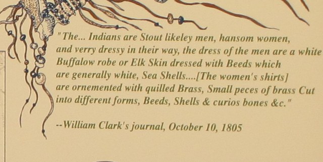
The verbiage on this sign reads (cuz I know you can’t see it cuz so small kine…):
Guided by two Nez Perce men, the Lewis and Clark Expedition entered present-day Washington on October 10, 1805. They beached their dugout canoes and camped at a site across the Snake River from here.
In this area, the explorers met, traded with, and recorded observations about the Nez Perce. These Indians, some of the most friendly and helpful on the entire journey, assisted by providing food, guides, and maps. Indian people had lived here for thousands of years and knew every practical river and overland route, as well as sources of food, water, and shelter.
From here, Lewis and Clark continued down the Snake and Columbia rivers, reaching their principle goal, the Pacific Ocean, at Cape Disappointment. They constructed Fort Clatsop, their winter quarters, among the Chinook and Clatsop Indians at the mouth of the Columbia River. In the spring, the Expedition passed by this place on its return to the United States.
We are now crossing the Wawawai River.

Here we go!

It was actually kind of exciting… I mean, we were now traveling into new territory ourselves. We crossed over onto Highway 128, just before we got into the town of Clarkston. Yeah, for William Clark. Of the Lewis and Clark Expedition.
Here’s a GoogleEarth da kine for you folks.


And here we are, on the other side of the river.

You may ask whydaheck are we going this way instead of straight on the highway. So ask. Okay, I’ll tell you. It’s because I inherited a spirit of wanderlust from my papa-san, who loved to explore new places. I love adventure, love the anticipation of seeing places I’ve never seen before. My papa-san probably had it in his DNA…from William Clark, no doubt. So if there’s a back road we can take that will get Nolemana and I where we want to go, we’ll take it. Because I am the trip planner, and Nolemana is happy to let me be.
I was all jazzed to see this sailboat. It reminded me of the times I’d go sailing with my braddah, Kaniela, and our papa-san, out and around Diamond Head. And yes, I am sentimental. Sailboats always remind me of happy times back home.


the skateboarder ever discover the downhill it’ll be like Sturgis thing.
Wow, so beautiful. Chief Temuut’su Bridge reminds me of da bridge in Hale`iwa. Tanks fo taking us along!
Wow, u take some cool trips Moki. Mahalo for sharing and taking us along.m/
Hi Mokihana! Thank you so much for contacting me, and sorry to be out of touch for so long. I can’t seem to get on Ravelry and have put it down to it being such a big site, and our broadband speed being so appallingly slow. I’ve had a very rough few months with problems with my elderly parents and it’s affected my health, but I now seem to be picking up again thank goodness! Glad you like the start of my new project.
I love the photos you took on your trip. Wonderful scenery! I hope you had a truly wonderful time.
How are the kitties? ours are thriving.
Hugs,
Shoshi