
We’re coming to the end of Da Mystery Road Trip Revealed. Ahahahaha. It only took me about a year or so. I think this post and one or two more are gonna do it, and then we’ll be off on another adventure.
Like Moses, we have now come down from the mountain, not with two clay tablets with the Ten Commandments on them, but with a wealth of memories to last us a really long time. We have one more mountain range to get through before we get home, but we will pass through it at sea level, on its fringes.
But don’t think the adventure is over yet! I still get plenny photos left to show you. So hold on!
It was now about 2:00 p.m., and Nolemana and I were getting hungry. We’d had our lattés mid-morning in Baker City, and now we had to find someplace to eat. Unfortunately, we didn’t know that TryLook had all kinds of information about where to go, or rather, we couldn’t figure out how to get to the info, but we knew we’d go into the next town and find something. And the next town happened to be:

Yep. We’re gonna stop in Pendleton. No idea where we’re gonna eat. We kept seeing signs for a place called Miss Patty’s, and we figured if we could find it we’d take a look.

Downtown Pendleton looks like another western town, similar to Baker City.

It”s bigger than Baker City, yet really is a small town in my book.

On the way to try and find Miss Patty’s, we came across this Heritage Trail Museum Park. Unfortunately we didn’t have time to get out and read all the signs’ information.

Try look this way cool statue! Sadly, I forgot to take a photo of the sign on it.

The Byrd Schoolhouse was moved here to be part of the Heritage Station.

Here’s some interesting info about it:
Byrd School House
Located on the east end of the museum, the Byrd School House was built in 1879, seven miles south of Pilot Rock on land donated by Maria Byrd. In the very early days, Byrd School was a tuition school usually operating for three months, or as long as a family could afford the expense.
Students rode horses to school or walked. When there was deep snow, their fathers often hitched up the horses to a wagon with sleigh runners and took the children to school.
In 1940, it was felt that busing the students to Pilot Rock was more economical than keeping the school open. For many years the building was used to store grain.
The building was moved onto the museum grounds by volunteers in 1990. Today, it has been restored to look much like it would have been 100 years ago. As you visit the school, visualize how eight grades were taught in a one-room schoolhouse!
One of these days we will go back and explore the whole museum, cuz try look:

Heritage Station Museum encourages you to experience the richness of the region’s fascinating history. Because there are so many facets to local heritage, the Umatilla County Historical Society chooses to pursue a “changing” exhibits philosophy in order to fully tell the story. There is always something new to see.
Pendleton’s 1909 train depot houses the exhibit galleries of Heritage Station Museum. Renovated as part of the facility expansion (completed in 2003), the building with its high, coved ceilings and interesting architectural details provides a portal into the past. Explore the galleries, brimming with exhibits that showcase the region’s unique mix of tradition and ingenuity.
On the grounds you’ll be able to ride the rails in the caboose, attend class in a 1879 one-room schoolhouse, and walk through an 1879 homestead.
I wish we could’ve seen this:
Fix Cabin & Homestead
A 16’x20’ hand-hewn log cabin is the centerpiece for the Homestead Exhibit. Built in Alkali Canyon about 1879, it housed the 10-member family of Monrod Fix. A small barn (replica of a one typical of the local homesteads), privy, root cellar, and water trough complete the setting.
A windmill, typical of those that dotted the local landscape, whirrs in the breeze. This windmill has a unique history: it was used to replenish water tanks on steam engines pulling trains through the Blue Mountains. Suspended beneath the blades is a wooden reservoir that held the water for the next train.
But we did get to see this:

Caboose
When Union Pacific Railroad decommissioned some of its cabooses, The Umatilla County Historical Society added one to its collection and sited it on the museum grounds. It is open so visitors can experience what it was like to ride the rails in the last car on the train.
The caboose played several important roles for the railroad: it served as the office where the business of the train was conducted, home to crew members as they traveled, and it was an observation post from which the crew could watch for problems with the train and tracks.
I’d been watching TryLook’s maps to see if we could find the way to Miss Patty’s, knowing that we could always program in the address that we’d seen on the highway signs. But suddenly, there it was! It looked like our kind of place, so we drove into the parking lot.

Now I need to tell you something about my car. My kawila. I’ve been put several bumper stickers and decals on it. Like “100% Tita”, for instance. That’s the one that gets the most comments from mainlanders. “What does it mean?” they say. I tell them, “It’s a local girl with an attitude!” Ha ha! Then there’s one that says, “Live Aloha”, and another that says “Aloha Happens” that I got from Kamaka Brown, a local kine stand-up comedian. Great guy, that Kamaka.
Of course, there’s my license plate, too, which says, “KOLOHE”, meaning “rascal”. So I’m pretty hard to miss!
All this to say, remember in the last post where I told you about another serendipitous thing that happened? Well, it happened at Miss Patty’s. Which, by the way, is a great family restaurant and a great place to eat.
Nolemana and I were eating our lunch, when a couple came in and came up to our table (there weren’t a lot of people in the place). The husband asked me if the car was mine, and I said it was. (Well, I did have on a local kine t-shirt which helped to identified me.) It turns out that he and his wife are also from Hawaiʻi, and were taking a long road trip across the US to see family. The guy was haole, and his wife was Japanese and spoke very little English, but the four of us managed to have a really delightful conversation. It was one of those really wonderful surprises that helped to make our whole week so wonderful.
Again, we wished we could have stayed longer, but we really needed to get back on the road again. So we said “aloha” to our fellow roadtrippers (is that a word?) and got back into the car. The one with the Hawaiian decals all over it!
Back on the highway again, we were, as Kikue so beautifully said, “sammiched between the sky and the land”.

About two hundred miles to go.

It was now about 3:30 or so, and since we couldn’t just turn around and go back to Montana, we were looking forward to being home again.

Not very many ranches dotted the landscape, and this one looked pretty isolated.

We’re maybe twenty minutes outside of Pendleton here.

There was hardly any traffic along the highway, even though Interstate 84 is a major mauka/makai road. This is about as trafficky as it got. And trafficky is too a word. Just ask our girls!

Gray skies, but no rain, which was really nice.

I really like the way the clouds look in this photo. Kinda like cotton candy.

And here is yet another temptation to stop! Really, this country of ours is so vast, with so many siren songs calling my name! I wonder how long it’d take to spend time in all of them across the United States!

Well, since we couldn’t take time to stop, I am so grateful for the internet, where I can at least get a small idea of what was beyond the highway. Oops. I think I just split an infinitive. Too bad. It sounds mo bettah my way.
Check out Echo’s website here. It’s worth a stop.
We took a photo of this overpass especially for Kikue. I love the way the horses seem to be running right across the highway.

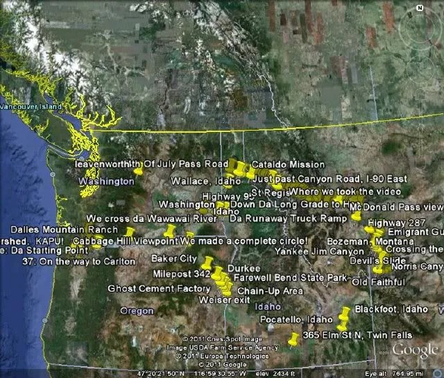
At just about this point, we have made a complete circle in our trip; just a week earlier, we had turned North to Umatilla, and from there on to Idaho, and then to Montana. See where we turned North?

When we get to The Dalles, we’ll be about an hour and a half from home. So we still have a ways to go.

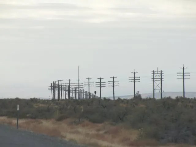
I like looking for photos in unlikely places. Like these telephone poles. I love the way they line up against the sky.

Maybe they are telephone pole sammiches? Hee hee.
And here again are all the trees grown for wood pulp that we saw on our first day of the road trip.

And of course, I wondered how many individual trees there were in all those acres! It was kinda strange seeing them again. I felt as though we’d been gone for much longer than a week, considering how many advenchas we’d packed into just seven days.

Getting closer to home.

And here it is again: The mighty Columbia River.
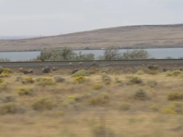
We are still on the Lewis and Clark Trail. I got a copy of their journal, and I want to know if the land looked just this way when they came through here. Was it this dry? I expect it was.

I know that the river was untamed when they came through here.

Here is this post’s “why is this here/what is it?” photo:

We are now entering Gilliam County. The Columbia River Gorge isn’t too far away now. I love it when the highway is above the river so that we can see how incredibly beautiful it is. The river, that is.

And here is our completed circle. I’m leaving in all the points where we touched down, so to speak, so the circle may be hard to distinguish. But a circle it was.
I can hardly believe there are only two more posts to go in this amazing advencha. I try not to upload too many photos at a time in case anyone is on dial-up. I have just enough left for two more posts before this particular saga comes to an end.
I so appreciate all of you who are still with me!

I especially love picture #13 (also my lucky numba) where the horizon is a really long way away with nomo mountains. Don’t get me wrong – I love mountains – but since I’m from Hawai`i, seeing THAT MUCH FLAT LAND is exotic to me.
Reminds me of when my oddah half and I were driving (well, HE was driving) across Canada to go to a friend’s wedding. It was the first time I’d gone that far east in Canada, and that stretch across Saskatchewan took forever. “What’s that dot on the horizon, dear?” I asked. “That’s Regina,” said he. Six hours later, “What’s that dot on the horizon, dear?” “That’s still Regina, it’s just a little closer now.”
I would have gone nutts over the horses galloping like that over that overpass. What a treat and thank you for thinking of me when you saw it. Makes me feel special!
Pendleton looks so Western! I love when you guys stop off long enough to take a few photos of quaint little towns like that. America is made up of so many of those little places tucked away. Each one with their own history of how it was birthed and struggled, made up of all sorts of people with stories of their own.
A circle indeed! Can you believe what an adventure you had?! Most people who haven’t left Hawaii has no clue what it takes to travel like that and what kind of tremendous adventure it can be. There’s nothing like it. Every time we go on trips by automobile I wish we had more time to explore. Never enough time, it seems.
Again, thank you so much for taking us ‘hitch-hikers’ with you! I am so grateful that you’ve decided to keep this travel journal going and not give up in the mid-stream.