
Ho, I neva thought it was gonna take me this long to do this post! The main pilikia was that panoramio.com is down, and I wanted to get permission to use somebody’s photo. I will link to panoramio and hope that it will work out pono for everyone.
In the last post, I showed you a photo of a sign telling about a really, really long downgrade. And we were about to go down it.
We were just coming out of the Blue Mountains, heading down into the Columbia Basin. We’d been through some beautiful forested areas, and I was looking through GoogleEarth and came across a photo taken by PG Holbrook at Panoramio.com that I knew I just had to have for this post, especially for AFK. I have waited for two weeks just trying to be able to sign into the website, and I keep getting error messages. I hope that the photographer doesn’t mind if I use this photo. I have given him/her as much credit as I possibly can.
At any rate, the photo was taken at Hilgard State Park, just at the junction of Highways 244 and 84, just out of La Grande, in the middle of the Blue Mountains. Eh AFK! Shaka da photo, yeah?

The park looks like a wonderful place to stop for awhile, doesn’t it? Even with the cows! Or should I say, especially with the cows!
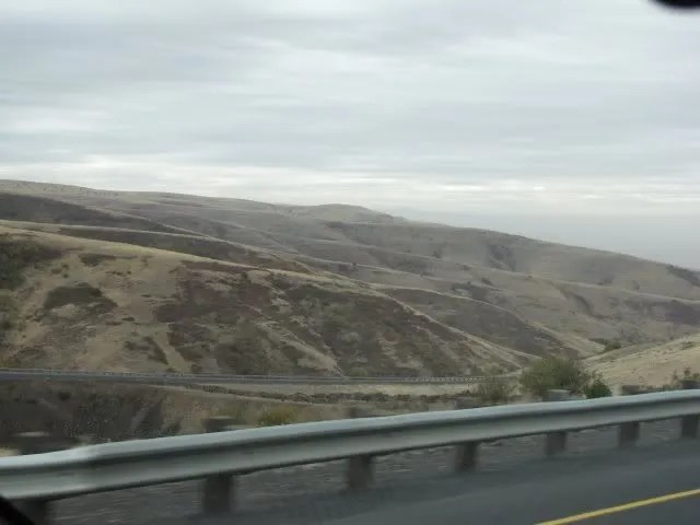
But after leaving the forest, we were again confronted with treeless beige hills. And if you look, you can see part of the downgrade in this photo.
I can’t help but wonder how long it took for these hills to get folded up like this. How many billions of years. Too bad we couldn’t have a time lapse camera that could show us!

When we saw the view, we just had to pull over. I was getting something out of the kawila, and Nolemana, da sneaky buggah, wen take dis shot of Musubi and me. And see that house up there? Oh my gosh, the view they must have! Oh, try wait. You can’t see it yet. Try wait!

I should warn you that many of these photos will look similar and that there are a lot of them. Now I wish that I’d taken a video showing the view, but like I said before, I was afraid we’d use up the rest of our memory card, so didn’t.
Nolemana took these with his camera. He and I were both snapping away; the view was so expansive and amazing.

Here’s another one:

I don’t know if you can see them, but down below us are acres and acres of farmland.

The wind was really blowing and it was a little chilly, but we kept snapping away. There’s no way that a photo can adequately show how gorgeous this view is!

Straight ahead, ‘way down there, is the river. It’s behind that green tree line.

You can’t see it very well yet, but in a minute I’m going to show you a really cool photo of the highway.

See that? We will be heading all the way down there as soon as we’re pau taking photos.

Talk about a winding road!

Now I’m going to tell you something about me that I’ve told you before, and that is that I’m easily entertained. Don’t need diamonds, shoes, makeup, cruises or anything like that. But what does entertain me is a view like this! I could have just sat there, gazing out over this view, for a very, very long time. I loved it!
And here’s another secret about me: I love views where I can show five different roads all in the same shot, their curves winding all over the place. I am thrilled with this photo! Can you find all five of the roads? All part of the same highway? Try count ’em!

I love it!! The roads look like they should be part of some kind of a board game or something. To me at least.

This shot even shows a gravel side road.

Where we are now is on Cabbage Hill, or more formally known as Emigrant Hill. I’m gonna show you a sign about it in a minute. The view is so magnificent that no photos can really do it justice.

Musubi waited quietly in the car while Nolemana and I walked around the viewpoint.

I am so grateful that there are people who are willing to preserve areas like this along Oregon’s highways!

Alas, we had to get back on the road again. I could have spent a lot more time here, but as usual, we still had a really long way to travel today. Heading down, we saw this interesting truck.

Here’s the sign da kine I told you I’d show you. I hope you can read it; it talks about how dangerous this road is and urges people to really be careful when traveling down the hill. Respect da hill!

The woodpecker truck was just ahead of us as we made our way down.

There were special mesh da kines to keep any rocks from tumbling down onto the highway.

And down we go. It would’ve been fun if I’d stayed at the top of Cabbage Hill and taken a video of Nolemana driving all the way down. Or vice versa.

We also should have timed it, to see how long it took us to get down to the flatland.

There’s the runaway truck ramp. I’m sure glad they have one of them here!

See that truck ‘way down at the bottom? It’s in one of the first photos of this post, just heading down the hill. Lots of fun seeing it this way instead of out in front of us on a flat road.

This is one of the steepest runaway truck ramps that we’ve ever seen, and I imagine they need it to be like this, especially if trucks lose brakes coming down this long hill.
We just kept winding down and down, and now we could see more clearly all the farmland below us.

Looking back at where we’d just been. I love that we were going down instead of up because the views are so much better that way.

Now the patchwork of farmland stretches out before us.

And we’re almost all the way down the hill. What a ride!

I was sorry that the road down had come to an end. I really enjoyed the view, the ride down, the curvy roads…but I guess you didn’t know that, yeah?

When the wheat is ripe, I bet this area is absolutely breathtaking.

As always, I wondered what it’d be like to be a farmer or rancher out in this beautiful country, and about what the pioneers saw when they first came down the hill in their covered wagons.

Here’s a GoogleEarth shot of where we were:
You know, I realize that we live in a big, big, world and that there are incredible sights to see in lands and countries all over it. One of my daughters has gone to Italy and France and Germany and just loved the experience. I will undoubtedly never get to do that. But you know what? It’s okay. I am so enthralled by this country I live in that I would love to explore as much of it as possible. Everywhere we go, whether it’s all the way to Montana or right here in the Pacific Northwest, there’s always something new and wonderful to see.
I’m a side roads kind of girl, and this road trip was so much more than I’d ever dreamed it could be, even though a good part of it was on major highways. And we’re not pau yet!
In the next post, I’m gonna tell you about yet another serendipitous and delightful part of our trip.

Wow, I LOVE that shot of moooooos in the parking lot! Thanks!!! What a beautiful vista. Some of the pix of Cabbage Hill remind me of the area around Hanauma Bay (before you see water).
Amazing photos. Some of it looked like ‘patch work’ under the sky. Sort of reminds me of a place I found in Second Life while on one of my hunts. At any rate, I love seeing the sky just ‘hanging’ there over the land. Sort of allows me to see how VAST it all was for you and Nole to be sammiched between the sky and land. I would think it makes a person feel rather tiny in comparison. My goodness, that was a long, long, long drive down it seemed from viewing the photos. Yes, it is ALL so wonderful to see. And so wonderful of you to allow us to see in this way too! Mahalo!