
So we left Baker City behind us, heading towards the Blue Mountains. We hadn’t gone very far down the road and had just passed under Imnaha Road, when we spied The Oregon Trail Monument. In case you wonder why it takes us so long to get anywhere on road trips, it’s not only because Mokihana hollers, “Train!” or “Barn!” or something, it’s also because she hollers, “Historical Marker!” I think Nolemana would have been content to just drive by, but guess what? He ain’t the driver. He has no control! Heh heh.
Actually, he’s a very agreeable kane, and even though he’s not nearly as interested in history as I am, he didn’t get upset when I wanted to stop here. Because it wasn’t just a historical marker, it was a whole series of them. I told him we wouldn’t stay long, and hadn’t I been trustworthy at the quilt store? Why yes, I had. So we stopped for some quick photos and today’s history lesson.
I took photos of every single sign. What you’ll see is first the overall sign, then the information about it, then quotations from the diaries of some of the pioneers who passed this way in the 1800’s. I hope you can read them okay.
Eh. Even if you’re not a history buff, this stuff is really interesting.
Here’s what the building looked like. See what I mean? It’s not just a historical marker. This point marks the beginning of the pioneers’ trek up and over the Blue Mountains. Or in Hawaiian, Nā Mauna Polū. See how much you’re learning today?

There is a covered kiosk da kine area where all these signs are, and here is the first one. The whole sign.

Info about the Lone Tree. Meaning that even back then, this was a treeless area.

From the diary of Medorum Crawford, September 8, 1842:

The Lone Pine was very important to the pioneers. Imagine that…the only tree for miles and miles and miles. How did it come to be when no other trees grew here?

And what a landmark it must have been to the pioneers, who now knew either relief that they were almost to their destination or fear that they now had to cross the Blues? Probably a mixture of both.
But because people can be stupidheads, the next sign told of a grievous event. “Some inconsiderate emigrant axe”? More likely some stupidhead emigrant jackass”. In my opinion.

From Peter Hardeman Burnett’s diary, September 27th, 1843:

Stupidheads. Now maybe they thought they had a good reason to chop it down, but my sometimes cynical mind says they were being greedy and never even stopped to think of the big picture. Maybe I shouldn’t be so cynical, but sheesh. It seems pretty obvious that the reverence for the land shown by so many native peoples was not present in the minds of the men who cut down the tree.
Permanent settlers. Don’t even get me started on Manifest Destiny.

Gold. It draws people like a magnet every time.

From the diary of S.B. Eakin, August 5th, 1866. He was apparently a blacksmith, and only twenty-two to twenty-three years after the earlier settlers came by, trains were already here. Amazing.

How kewt, yeah? The “Boo” Mountains.

I guess if I’d been traveling in a covered wagon, the Blues would have made me just a bit uneasy, seeing them steep ahead of me.

From the diary of John Johnson, July 29, 1851:

What’s really amazing to me is how fast the beginnings of a new civilization began to take over the area. What land had formerly belonged to the Native Americans alone was being taken over by the haoles. Don’t even get me started on that, either.

Okay, I won’t rant. I just wish things could have been different for Native Americans, for Native Hawaiians, for all the people whose treasured lands and ways of life could have been accepted and respected. But I digress. History has a way of doing that with me.
Eh AFK… u no stay da oni one who likes pīpī…oni ting, u like collect dem, not eat dem. Right? Oh. Well… umm… next frame, please. Move along… head ’em up, move ’em out…. ♪♫

From the journal of Sarah Sutton, August 13, 1854:

This sign points out that the Oregon Trail was not just a single lane of a rutted road.
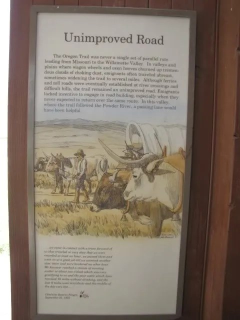
I can certainly understand the settlers’ lack of desire for road-building if they thought they’d never be back this way again.

From the diary of Charlotte Stearns Pengra, September 21, 1853:

The Willamette Valley was their goal. On the makai side of the Cascade Mountain Range, the land was fertile and green.

I give the pioneers a lot of credit for making such a difficult journey. Would I have been willing to do it? Of course, back in those days, if a husband said, “We’re going”, what choice did his wife really have? I’ve read a lot of pioneer journals, and the women went along whether they wanted to or not, often leaving prosperous farms, and certainly family and friends, to follow their husbands on this arduous trip.

If you look closely, you can see the red line signifying the Oregon Trail over the Blue Mountains (I marked them in blue), and then the North-South Cascade Mountains beyond.

This map showed the entire route of the Oregon Trail, from Independence, Missouri, to the fertile Willamette Valley of Oregon.

So here’s another part of that map… now you can see how far it is from Baker City to the Blue Mountains crossing. At how many miles per hour? Seeing the map is one thing; reading the pioneers’ accounts of the long way from there to here is something else.

From the diary of Sarah Sutton, August 13, 1854. Being able to read pieces of these journals is a real privilege to me.

Sometimes, when working on my road trip advenchas, I think in some rather convoluted way (what’s new?) that I have something in common with the pioneers. They documented their travels with pencil or pen in journals that were thankfully preserved over time; I do the same thing with a camera and a computer, and I zoom along the highway at 70 +/- mph. They were lucky to go twelve miles in a day… that’s maybe one mile per hour! And many of them walked the entire distance! Everything they owned was in a covered wagon; I’d only taken along enough stuff for eight days on the road. They had to work hard at every stage of the trip; Nolemana and I traveled in comfort. Yet here we were, following the same route through desert and mountains over a hundred and fifty years apart.
My blog isn’t worthy of the history books; I’m not even making history. But my blog reflects a personal journey (at least for me it does), and if you read between the lines, you will see me as a person who loves the serendipitous events and places that pop up during the trip that fill me with wonder and awe and fill my heart with laughter. Like the unexpected cattle drive near Drummond, Montana, and the pōpoki in the bookstore. Each one of these events adds to my storehouse of blessings, and everytime I add a photo to this road trip advencha I re-experience the joy that I felt when they first happened.
See… I’m a seeker. I stop at historical markers because I have a thirst for knowledge. I pay attention to stuff that others might just pass by. I take less traveled roads just to see where they go. I’m not content to just plod through life… I want more. Maybe that’s the pioneer spirit in me. I probably would have volunteered to take the first canoe across unknown seas to the Hawaiian Islands or a covered wagon to Oregon. Hmmm… I think I might be digressing just a bit.
Pondering what we’d just seen, we got back into the kawila and headed back out onto the road; I was grateful for the ability to take photos and document what we’d just seen and be able to re-experience our journey later as often as I wanted to. And yes, to share it with whoever of my friends was interested in reading about it.

The blue, Blue Mountains.

I do a lot of thinking in the car. Nolemana and I talk about what we’re seeing, but lots of times we just ride quietly along, lost in thought. The vistas were so amazingly beautiful that it’s hard to take it all in.

Six miles out of North Powder, Oregon. It used to be a stage stop before the railroad went in, and would be another interesting town to visit. Population less than a thousand!

We cross a small river. And eh! What do I see there up in the left hand corner?

Why yes! It’s pīpī! AFK will be pleased. I cropped da photo for you, tita.

And yes, I did holler, “Pīpī!!!” I knew you’d ask.

“Eh! Wea u stay going? Come back! AFK like see u!”

This one wanted her photo taken.

This one, however, kept walking away.

I particularly like this shot. Pīpī and wind turbines. Interesting contrast, I think.

The last time we saw a sign like this, we were in Yellowstone. We’d been traveling south of the line of demarcation and now we were back up to it again.

We’re now less than three hundred miles from home.

In the next installment, I’ll be posting photos as we travel over the summit of the Blues and I’ll show you photos of another really wonderful serendipitous event! Will I be so introspective again? Dunno. It seems to be happening a lot more lately!
Mahalo for riding along!

WOW! This was very educational! Though all were very interesting I can’t shake the feelings I have about the Lone Pine! That was absolutely…. well, how can I say…. I guess I will not say it. After all, the right words would only cast more negativeness in the air. It seems history will always repeat itself as long as there are such human beings in this world. Geeesh.
The entire trip, the study (very small one on my own) about the Oregon trail is so fascinating. I think the same way too. All those people who traveled practically inch, by inch, not only having to endure, at times, abusive weather, but how many of them fell to illnesses? It certainly was not easy! And yes, my thoughts included how it is for us today as we race across the country in practically no time in comparison. Air conditioned vehicles, the best rest stops along the way, and lodging too. My goodness, we came a very long way.
However, every inch the white man traveled into Indian territory, it was two or three inches that the Indians lost forever. Not only in space, but also in way of culture and even breeding. It is a sad thing that their land was ripped from them in such a hostile, unfair way. If only we, as humans, were able to respect the land we live upon FIRST, above all else. If we did, we would never have thought that land could be OWNED and kept away from nations. There would be no boundaries. How sad that part is.
Again, another wonderful trip riding shotgun with you Moki! Thank you so much for taking the time to share your experiences with us. I feel honored and am very blessed by it. 🙂
I had the same thought about the idiot who cut down the Lone Pine as you and Kikue-san. Bakayaro.
Mahalo mucho fo all da pīpī pix! Made me laugh! Wen my oddah half and I see dem, we “Moooooooooooooooooooooo” at dem!
I think you get more out of your journeys than most people, in large part because you enjoy the journey and not just arriving at your destination. And a big “maika`i no” to Nolemana for not fussing at you and enjoying the journey too.