
Nolemana, Kukui, and I woke up to a bright sunny day in Ontario, Oregon. The Holiday Inn where I’d made reservations had a restaurant right next door, and I’d also signed up for a dinner coupon, so that’s where we ate. Well, not Kukui. She had her usual boring dog food. The kaukau was good at dinner, so we went there again for breakfast. Musubi waited out in the car. This was a great motel. While we were signing in another wahine was there signing in at the same time. She’d travelled from Colorado and was heading back to Seattle, making the trip alone and loving it. She said that she allots herself an eight-hour driving day, and wherever she is at the time, that’s where she stays. Well, not in the middle of the desert. Who’s da lolo who wen say dat? Nolemana helped her carry her bags up the stairs (no elevator). Really nice lady.
We knew that by the end of this day, we’d be back home. It was going to be a very long day, so we didn’t linger over breakfast.
Our kawila was waiting outside our room, which was very quiet and located at the back of the motel.

Musubi was patiently waiting for us in the car, still excited about his new cape.

Even now, the next morning, I had wai maka, knowing that we’d left behind Clare and her ʻohana after much too short a visit. Clare and I were determined to keep the secret of the mystery road trip. And yeah, it seemed impossible for a couple of Portagees, but we did it! And well, I might add!
We drove out of the motel and saw the sign pointing us makai towards home.

The last time we’d been this way had been years and years and years ago, when Nolemana and I moved from Twin Falls to Portland. Leilani was just a year old back then, which hardly seemed possible. At that time, it was snowing almost all the way to Baker City, but this day was clear of everything.
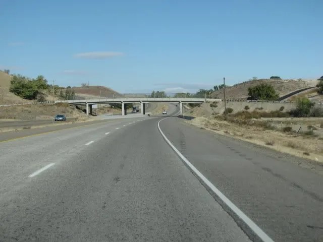
Our first Portland sign was right after we got onto Interstate 84 / Highway 30. It looked good, really. I just wanted to be in two or three places at once is all!

There was a little bit of fall color alongside the road.

Now I will apologize in advance for the lack of information about exactly where we were for the rest of the trip home. Nolemana and I have perfected our photo travel journey since, but at this time our notes were pretty vague. I have used Google StreetMaps to try and figure out more precisely where the photos were taken, but I’m not having too much luck. That little gold man doesn’t move very fast, and I just don’t have time to travel every inch of the freeway with him. E kala mai. Sorry.
I loved the sweeping curves of the highway. And as somewhat of a defense, I know exactly where we were here. Just a bit northwest of Ontario. Ahahahahaha.

We’re still pretty close to Ontario here.
This is at Milepost 372 just before Stanton Boulevard. It sure would help if GoogleMaps would show every single milepost along the way!

We are now pretty well leaving Ontario, with the road stretching out before us again. Everything looked really dry.

We’re climbing up into the mountains. This part of the highway is known as the Old Oregon Trail, and it’s the route the pioneers took on their way to Oregon. Imagine going into this country at just a few miles an hour. Did they wonder what was ahead of them? Had some mountain man tell them of the Blue Mountains and the Cascades? Or were they just winging it, not knowing what lay ahead? Did they think this desert environment just went on forever?
Clippity clop, clippity clop. Slowly over the mountains, and not a tree in sight.

I tried like crazy to find exactly where this was, because I love how it looks, but to no avail. What I can tell you is that it is ten minutes outside Ontario. I can’t find on GoogleMaps where this division in the highway is. Mebbe I too blind mullet anden. I also think that because Nolemana would often use the zoom on my camera, the view was sometimes different than I could see in StreetMaps. But you’d think the aerial view would show it. Again, mebbe blind mullet.

Milepost 366. We took this photo because chaining up here seemed so incongruous (ho da big word, yeah?) when there was no snow on the ground. You know, kinda like an oxymoron lidat.
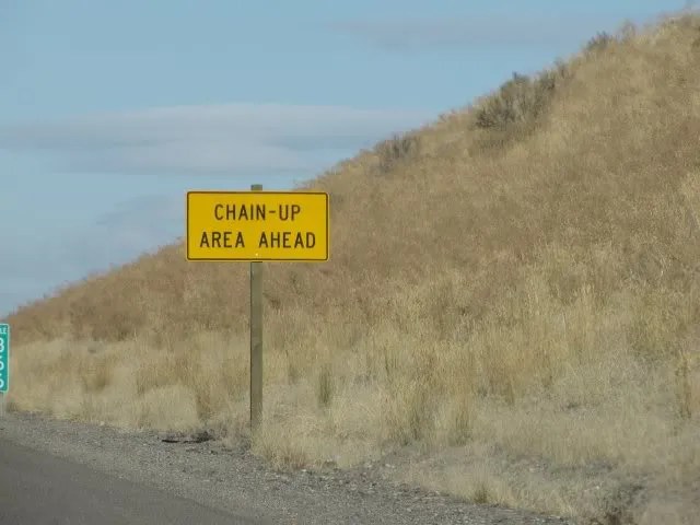
Now I’m not stupit. I know this is a snow zone. But again, oxymoron on a day like today. But I have movies (which yes, I have transfered to DVD) of us crossing these same mountains when it was snowy.

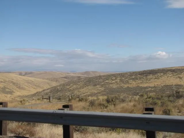
I would have a very hard time living on a ranch ‘way out here in the middle of nowhere. But obviously someone does; at least they run cattle here. Well, at least the land is fenced. But I don’t see how cattle could survive here. Though in spring and early summer maybe there’s grass.
Now here you can see mo bettah where we are, approximately. From green, irrigated fields up into the dry barren mountains. Though when the pioneer families came through here, I wonder if it was even green.

Try look. No trees. Not a single one. But what an amazing vista!

Why do I love these sweeping views so much? Dunno. I just like the curves, going down, going up, seeing where we’re headed.

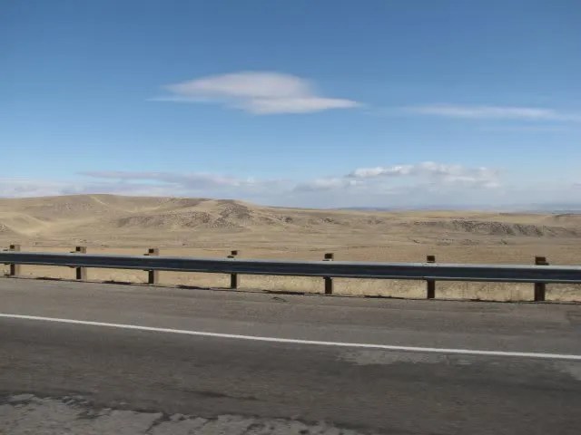
The sky was huge, and there was a lot of sagebrush down below. The land here was not fenced at all.

I tried zooming in on this photo to see if I could figure out what exit we were near, but it was too blurry. I think it might be near Moores Hollow Road, but don’t quote me on it. If somebody knows, lemme know!

Again, plenny sagebrush. Plenny sky. Plenny highway. But I have no idea where we’re at except that we’re now fifteen minutes makai of Ontario.

I think these are cattle pens or a stockyard in the distance. We were still struck at how barren the area looked without any trees.

No worries, brah. I promise we no going pass any snowplows. Right, left, ontop oa anywea!

Eh! I said I wen promise!

My guess is that we’re pretty near the summit here. I think. Is there even a summit?

Oh. I think this is it. Talk about being able to see for miles and miles!! This was a fabulous view, and we slowed ‘way down in order to get a nice clear shot. It’s not like we were in the middle of Portland traffic or anything. There were hardly any cars or trucks on the road.

I did a GoogleEarth da kine so you can see approximately where we were and what it looked like from up high.

Guess what that is. Nope. Nope. Guess again! Nope. Okay fine, you give up? I tell you. The Snake River! We have been kind of following it ever since Idaho!

We are now definitely heading downhill.

We are now near Milepost 358, near the exit to Highway 201, which heads on out to Weiser, Idaho. The Snake comes fully into view. Can you imagine how the pioneers felt when they saw this mighty river after travelling slowly through that desert?

Tempting to head right on back to Idaho and Clare dem, but we kept going. Actually, we could’ve headed back to Idaho, then back on up to Montana to see Cousins! Have I said I love Montana? I love Cousins even more!

So ends this part of the journey. We still have a long drive ahead of us, and I hope you’ll stay with us and see wassap!
A hui hou….

Mahalo fo’ anodda nani trip through America. Too good dis. m/
I know what you mean about the incongruity (!) of a “snow zone” sign when it’s so not-snowing. I was thinking yesterday about the big fences in the middle of nowhere I saw when we were travelling last year. My odder half told me were snow fences to keep snow from drifting onto the freeway. Those same snow fences are getting a workout now.
When you were On Top of the World, did that Carpenters’ song run through your head?
As if no can tell arreddy dat you one local sistah, I love dat you said “makai of Ontario.” Ocean is couple hundred miles away an den!
Nice road trip. Cool travel journal.
Mahalo so much for sharing da advencha!
Talk about miles and miles of rolling hills but no trees! Looks like the desert to me, much like where I used to live in Riverside, CA. Nothing but nothing. What do you guys talk about is what I wonder. That is a lot of miles, must have a lot of conversation too. You are very blessed to have a hubby that doesn’t mind traveling and talking. LOL Again, great photos and very informative. You must have kept a diary or journal because your memory seems to be so sharp about the details on this trip. I’m amazed.
I love how the air smells in that kind of area, the sage brush is spicy.
I like the sweeping views, too.